Wednesday, January 1, 2020

Lookout! Mountain 50 Mile

I’ve been told the word “pleasant” and “50 miles” don’t belong in the same paragraph… but guys... listen… for real tho… I really did have the most pleasant 50-mile race in Chattanooga a few weekends back.

pic: Lavender Roots

For the past few years our crew has made the trek up to Chattanooga for the Wild Trails Lookout Mountain race weekend. Whether it be the 50 miler or the 18 miler, LM50 always serves as a good excuse to get the guys together for a fun weekend of trails and the typical debauchery. 


Lookout Weekend is kinda like taking a trip to the beach… each time you get a lil smarter with what you bring and where you stay. One of the first years we went up on a Friday night and came back after the race. Bad idea. The following year we rented an Air BnB on top of Lookout. Better idea but the hostest with the mostest was a little off putting when he unexpectedly swung on by to hang out… for an awkward and extended period of time. He did offer us the food in the fridge/freezer… which was nice… except one of the items was a half-eaten Wendy’s Frosty. Yea. Kinda weird… but the view was nice!


This year OJG hit the nail on the head and booked a loft downtown. This bad boy had a ping pong table in the living room!


And in the lobby of the building there was a bar, pool table and poker table. Place was legit. Bode if you’re looking for a cool ass spot for a home base in downtown Chatt.


This year’s race day turned out to have almost perfect conditions. The start of the race justified wearing gloves, but temps stayed comfortable in the low 50s most of the day. I was content and cozy all day with a pair of arm sleeves and a neck buff.

I’d learned from previous Lookout Mtn races that it was best to go out a little fast while on the asphalt to avoid the conga line. I went out fairly hard to distance myself from the pack… and by fairly hard I mean… I jumped ahead of the majority but still watched the lead 50 and 18 milers disappear ahead of me before I even dipped into the single track. My personal goal for the race was to finish in the top 5, but mostly I just wanted a solid race through and through. I had DNF’d the Ransack 50 (aka: Rebecca Mountain 50) in September due to the inability to keep anything in my stomach from mile 18-30 and I really just wanted to cover 50 miles happy and with minimal issues.

Not so fun fact: I’ve only DNF’d twice in my life. Both at Ransack 50. I don’t want to and have sworn I’ll never do that race again… but track record shows that my dumbass will probably sign up again despite KNOWING how bad the heat/humidity will be... 

Ransack 50 DNF #1
pic: Gordon Harvey

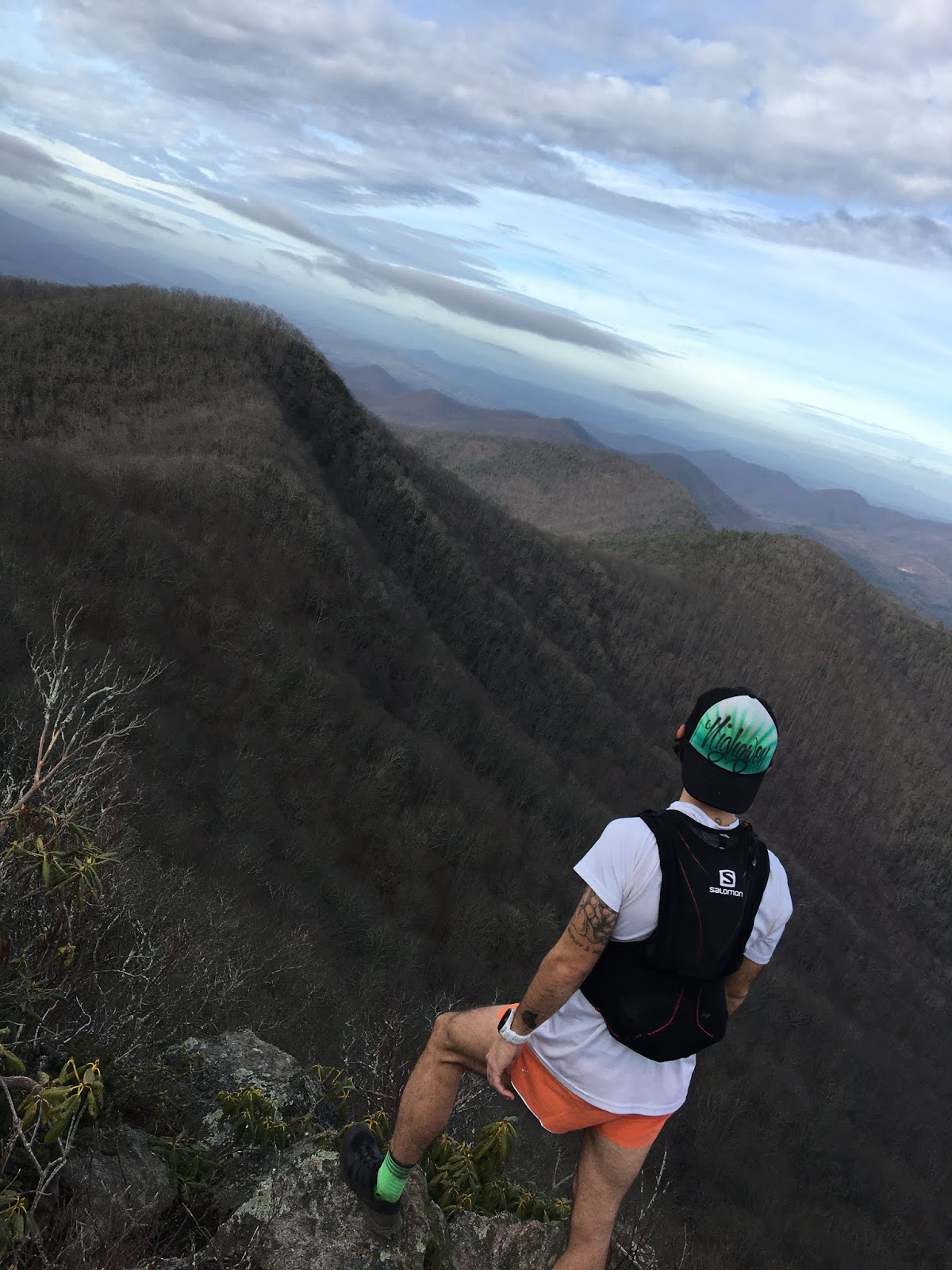
As I cruised along the Bluff Trail I was reminded why I enjoy the Chattanooga trail systems so much. The trail hugged the side of the ridge with great views of Lookout Valley below and towering rock facings above. I moved comfortably and easily along the trail.

pic: Lavender Roots

I removed my gloves right before I started the descent down to the Craven’s House aid station (mile 8.2). I stayed observant and relaxed on the descent to avoid any hidden leaf-covered obstacles but got to open up the stride a bit when we hit the gravel road at the base. I was sitting 3rd as I moved quickly in and out of Craven’s. The next 5 miles were uneventful. I had run this section in previous years, so I knew the section and what it offered. I filled my water bottle as I came through Blue Beaver Aid Station (mile 13) and picked up the pace as I left. I knew the trail would be flat for the next couple of miles and wanted to cover some ground quickly before the slow climb back up to the college. I got caught off guard when I heard someone creeping up quickly from behind. I glanced down at my watch at the 7:30 pace and thought “well damn… this dude must be flying!” I young, chipper collegiate runner (not part of the race) settled in beside me. Since I had pretty much run alone the entire day, I welcomed the company. We chatted for a mile or so before he turned around and headed back. As the trail started to climb, I sort of shut down any thought process and slipped into the rhythmic run/hike trance that Ash has so thoroughly ingrained in my soul. Despite the climb being steady for 2 miles, it felt easy and passed by quickly. As I reached the upper section of the climb, I saw Andrew in his super subtle South Africa shirt a few switch backs ahead of me.

“Don’t you f*ckin’ dare let me pass you Andrew!”

I stuck to my rhythmic trance and eventually caught up to him and we chatted for a bit before I moved ahead of him. I told him I wouldn’t give him a hard time for passing him, but I couldn’t say that OJG and Matty Fierce would do the same.

I came through the start/finish (mile 18) area in 2:32 feeling smooth.

pic: Lavender Roots

“Are you ok? Hahah are you even breathing?”

pic: Lavender Roots

Since I stayed within my limits and wasn’t pushing super hard, it honestly felt like I had just started the race. I quickly refilled my bottle, grabbed a few fig newtons and happily headed back onto the trails.

pic: Lavender Roots

I had never run the 50-mile race route before so was looking forward to seeing some new areas. Before the race Matty Fierce had told me that the section after the aid station was long (9ish miles) and that I should be cautious with my nutrition and water intake. I kept that in the back of my mind as I moved along the easy rolling cross country route. After passing under some power lines, the trail dipped back into the woods. Years and years ago when I came out to crew one of my buddy’s 50 milers, I had run the section from the road to Lula Falls and back just to get some mileage. In my mind, I had figured the aid station was where it was last time (near the actual Falls) so I didn’t pay much attention to the tent set up near the wooden bridge in the distance. When I popped out into the clearing, I heard someone mention something about a cookout, so I assumed the tent set up was simply a part of that. I would soon find out that I was dead ass wrong. I finished off my bottle as I started getting closer to Lula Falls... pretty certain in my thinking that the aid was coming up. I popped out of the single track to find a taped off path (kinda like a finishing chute). I saw this massively beautiful spread of food/drinks/whiskey and thought… now that’s a pretty freakin’ nice aid station right thur! But something seemed off… I quickly noticed there was no way to actually get to the glorious feast. I slowed to a walk…


“This the aid station?”

A few weird looks were cast my way until some dude finally shouted.

“Nah man. But ya need something?”

For a second, I thought he was joking about it not being the aid station… but then it sunk in.

Thanks, but I’m good.”

I lied and started running again. I was kicking myself for the mistake as I passed by Lula Falls and climbed the rope to the ridge. I allowed myself to be pissed off until I got to the top of the ridge. I utilized OJG’s positive energy transfer to get myself back into a happy frame of mind as I moved along the slight but consistent incline. I finally popped onto a driveway and started the steep descent down to Nickajack Road. I rolled into the Nickajack Trail Head parking lot and linked up with my crew. 

pic: Kyle Stichtenoth

I was excited to see them and thankful the guys stuck around after their own race to crew me! I'm extremely blessed to have these fellas in my life!


I gave a fist bump to my buddy Ryne Anderson and a quick pet to his doggo before heading into the woods again towards the Long Branch Aid Station (mile 33ish). I grabbed a couple of grilled cheese squares and chatted to the aid station volunteers briefly before setting out on the 4-mile loop. Everything I’d been told about the loop didn’t have me looking forward to the experience. The loop wasn’t all that difficult, mostly just rolling hills, but the tight turns were frustrating at times. I made good time on the loop and got back to the barn quicker than I thought I would. I scarfed down a small cup of noodles and cheerfully started the trip back to the college.

pic: Lavender Roots

I grabbed a second handheld when I met up with the crew again at Nickajack. I wasn’t about to take the chance of missing the Lula Lake aid station again and go waterless for the final 8-10 miles! At this point of the race I started coming face to face with a lot of the 50 milers heading out towards Nickajack. I saw Pete Shearouse along the road and then AJW near Lula Falls. Both seemed to be in good spirits. As I crossed back over the wooden bridge an aid station worker yelled and asked if I needed anything. Since I had an extra handheld at this point, I just smiled and kindly declined. I could feel myself slowing down around mile 41. I had hit a lull and settled into an a gear I just couldn’t get to shift. I noticed a dude in a red shirt creeping up behind me. I kept him off all the way until the power line where he slid past me. I tried to pick up my pace but just couldn’t get motivated to push any harder. I saw an excited Hump as I crept up the final climb…

“Zeeger! You got this man! He’s just right ahead of you! Get it!”

This genuinely gave me a burst of energy and the push I needed. I opened the stride for a final push, but it was just a lil too late. I had been bested by a whopping 20 seconds. I laughed as I came through the finishing chute… partly because I found it funny that I really did have more energy in the tank but just couldn’t seem to access it to push for a podium finish… but I think it was mostly because of what my friends got the announcer to announce over the loud speaker...

pic: Matty Fierce

All in all, it really was a pleasant day on the trails. I walked away with a 4th place finish in a time of 8:55.

pic: Matty Fierce

After a few days of muscle soreness and antalgic gait due to a tight medial knee… I hopped back in the mountains the following weekend for the annual post Lookout Weekend trip over to the Walsh’s!

 18 miles of N. Ga mountains with Dayquon!


Lookout Mountain 50 and a relaxing weekend in the mountains was the perfect way to wrap up another good ass year roaming this beautiful planet.

pic: Ash

Cheers to the end of great decade of mountain memories and to the many more yet to be made!

pic: Ash

Wednesday, December 18, 2019

Big Bulgin' Birthday Bunion


“The researcher is really trying to examine each information source and find evidence to support a theme when they’re going through the triangulation process.”

Triangulation. Triangle. Pyramids. Pyramids are triangles. There’s an outcropping in the Smokies that some call The Pyramid…


And just that quickly, my mind rocketed away from Dr. P’s in-class lecture on data analysis in qualitative research and straight into the vortex of one of my most researched routes in the Smokies. For years I’ve dreamt about seeing the Smokies from a different perspective. I’ve scurried off trail a few times to explore a few cool areas like Little Duck Hawk…

pic: Ash
(can ya see the tiny lil Zach climbing the rocky ridgeline?)

But never could seem to find the time to set out on the one route that always lingered in the back of my mind.

pic: Ash

But there I was… early October… 11 graduate classes into the year and knee deep into a +20 page research paper on the effects of mental health on collegiate athletes…

I sighed and whispered out loud as I typed the word burnout into the heading of my next paragraph.

“I need to get away. Maybe I should take the Friday off before my birthday and just do it?”

Alexis having no clue what I was referencing looked up from her laptop with her always encouraging self, “Dude… you should totally do it!”

2019 had been one of my toughest years. I traded a high stress/toxic work environment for a low stress/healing work environment so that I could add a new stressor… graduate school. Yep. I went ahead a did that thing I swore I would never do. I went back to school.


I figured being a full-time grad student, full time employee and being a volunteer for the Make A Wish Trailblaze Challenge would be enough to push running to the back seat, but surprisingly enough, this year’s running exploits had been solid. I think having to really learn to manage my time a bit more helped establish a more efficient running schedule and routine. Instead of being all willy-nilly about my miles, I started being more regimented with my runs and training. To be perfectly honest, the first time I actually train trained for a race was for Pinhoti 100 in 2018. Ash outlined a baseline structure of a training plan and followed it to a T and ran my most successful race to date.

pic: Matty Fierce 


Although I couldn’t give my full attention to another training block like Pinhoti, I manipulated a training block the best I could to have another solid outing at the Hellbender 100 in April of this year.

pic: Whiteblaze Marketing

I found that I enjoyed racing more when I was pushing myself a bit harder. I had always just gone out with the intentions of finishing races, but I’ve discovered there’s something extremely satisfying in putting in genuine effort, having a plan and seeing how (or if) it comes together. This makes racing a blasty blast while at the same time making those long, unstructured mountain adventures even more enjoyable.

The next day after class, I walked into the clinic and asked the ladies, “How do yall feel about me taking off the Friday before my birthday so I can link up a long mountain weekend?”

“Yea of course!”

God I love my new job.

Before I get into the details of this adventure lets go ahead and get all the “but isn’t this dangerous?”, “what if you have to be rescued?”,that sounds dumb and irresponsible” bullshit out of the way. First and foremost, I’ve always been extremely cautious and have thought through, researched and weighed the risks of each one of my adventures. My risks are calculated with the simple premise surrounding coming home safely to the love of my life, Kati (aka – Dark Princess). And for this specific adventure… I even took an extra step (mainly to ease the mind of OJG’s wife Katie) and took a GPS tracker, bear spray and packed enough supplies and clothing to spend daaaaaaaaays out in the mountains if this went poorly.


The researched route I’d been wanting to do for so long starts at the END of Porters Creek Trail, goes off trail for approximately 2ish miles, climbs up Charlies Bunion and ends with a nice little trek on the AT. There isn’t really a simple way to complete this route… especially alone. Ideally… if I had a partner… we could park one car at Porter’s Creek Trail and another at Newfound Gap. This would make the total trip around 9 miles. Well… I didn’t have a partner and wanted an ALL-day adventure for my birthday, so I took a lil looksy at the GSMNP map and mapped out a tough lollipop…


The route I decided on was approximately 30 miles. The plan was to start out on Alum Cave, head up LeConte, descend Brushy Mountain Trail and connect Porters Creek Trail. At the end of Porters Creek Trail, I’d bushwhack and spend approximately 2ish miles off trail navigating up to the ridge below Charlies Bunion. I’d then climb from the base of the Bunion, connect with the AT, take Boulevard Trail up to Cliff Tops where I’d meet Ash and Bailey for a beautiful sunset before descending back down Alum Cave.

OJG offered up a spot at his cabin the Thursday night before I was to set out on the Big Bulgin’ Birthday Bunion and after a long drive up from Alabama, I was greeted by Matty Fierce with a tall glass of whiskey and a chair on the back porch. I’ve been beyond blessed with some of the best damn friends imaginable.


I woke up to 2 chipper and perky lil faces staring at me from the edge of the couch. Kate and Sela (Matty Fierce’s youngins) were ready to start their day. I wasn’t. The simple fact that I woke up on the couch instead of the upstairs bedroom was a pretty good indicator I may have had a lil tooooo much to drink on the porch! Oh well… the toxins would seep out throughout the day. I walked out onto the porch and was greeted by the most perfect day.


I had sworn to myself I would bail on the whole thing if there was even the SLIGHTEST chance of rain. The route involved traversing an area that gets devastated by flash floods and I had no intentions of risking that or slick sandstone on the climb.

After one final run down with OJG, Katie and MF of my intended route, and a “last known photo,” I set out for the hour or so drive to Alum Cave trailhead.


I arrived at the trailhead at 9:30am… a solid 2.5hrs behind schedule. I wasn’t on a super tight schedule but wanted to leave myself a good amount of daylight to navigate the off-trail section in case there were any unforeseen issues. I did a quick gear check, scarfed down a Clif Bar and set out for a fun day of exploring! Despite the overcrowded Alum Cave and heavier than normal pack, I made pretty good time up the mountain.


As I descended Trillium, I came face to face with the llama train carrying the supplies up to the lodge.


I took a small break at Trillium Gap to eat another Clif Bar and turn on my GPS tracker. I’d been up to the Brushy Mtn summit multiple times but had never had a reason to take the actual Brushy Mtn Trail. Surprisingly, it was a satisfying and free flowing descent! Thankfully by the time I reached the bottom of the trail to connect with Porters Creek Trail, the pesky whiskey hangover was gone.


As I made my way down the 2.7-mile Porters Creek Trail, I couldn’t help but think about the one person that inspired me to do this route, Jenny Bennett. A line from one of her blogs had always stuck out to me…

"Porters Creek and Lester Prong in the Greenbrier form pathways for rockhoppers that lead to mystierous and difficult places." 

And that's EXACTLY where I wanted to go... somewhere mysterious and difficult. 

Blue Ridge Outdoors wrote an excellent article on her life. 

Her story even inspired me to write a song called “TheLast Stream” under my acoustic folky side-project band named Anakeesta Sun

I walked through the camping area at the end of Porters Creek Trail and slid down an embankment to drop into Porters Creek. I was a little over 16 miles in when I left the actual trail and headed out on the adventure I’d been waiting to do for years. As I rock hopped down Porters Creek, I silently wondered where Jenny’s body was found.


Porters Creek was relatively low and navigating the rocks was simple and straightforward. However, the further I traveled up the creek, the tougher it got. I started passing over small cascades that were covered in moss and slippery rocks. Since I was alone and had no cell service, I had to be extra careful with my footing. One tweaked or busted ankle could be a potential life-threatening situation. But this place was everything I had hoped it would be. It was remote, beautiful and felt like I had stumbled upon a lost and forgotten ancient world.


I continued to meander and navigate the slippery Porters Creek until I finally arrived at the Lester Prong junction. I bid farewell to Porters Creek and continued my journey up Lester Prong.


The surroundings become more unnerving the further I traveled up Lester Prong. I had read numerous reports about the flash flooding in the area, but words can’t put it into perspective. Signs of flash flooding were ERRRRYWHERE. Massive trees were haphazardly scattered throughout the ravine, piles of big rocks and mounds of dirt were chaotically pressed against the rock facings. It was a haunting reminder of how powerful nature can be.

I started to become more alert the further I went up Lester Prong. It was imperative that I took the 2nd tributary off Lester Prong. Every tributary would take you to a different ridge. Take the 1st and you’ll have your choice to head up The Pyramid and Falcon Point on your way to the REAL Bunion OR take Middle Ridge to the AT. Continue following Lester and you’ll end up climbing the Jump Offs. But neither of those were the day’s destination... my intentions were to take the 2nd, scurry up the ridge and climb the Tourist Bunion. The Tourist Bunion is what most people refer to and have come to know as Charlies Bunion, however, there’s also a very very small and select few that call this “Charlies Bulge.”


It wasn’t necessarily difficult to figure out which tributary was the 2nd, but it wasn’t exactly easy. Once I started going up the 2nd tributary the environment turned rough. The walls of the ravine started getting extremely steep and left me wondering when/where I was supposed to start making my way up the ridge. Everything I’d read was pretty vague when it talked about finding a spot to start veering up to the ridge below the Bunion. I took it as a “just find the best looking path and go for it” kind of approach. I came to a massive boulder that had been lodged between the walls of the ravine. It was about a 5-foot ledge to get to where the boulder was stuck, but there was no real way around the rock. I back tracked a few yards and decided to climb up and work my way around the rock. This proved waaaaaaay more difficult and sketchier than it initially appeared. I climbed up about 15 feet to the left of the rock and started slowly inching my way along the steep embankment. The ground was loose and unstable. I semi-worried that the ground would give way and I’d fall the 15 feet down onto the hard rock floor. After a few minutes of slow, heart racing movement, I came along the opposite side of the lodged boulder and continued up the tributary. Things started getting hairy again in the ravine, so I finally decided to just take the chance and start veering upwards along the ridge. I can’t even begin to describe the thickness of the rhododendron and steepness of the grade I was climbing. Multiples times it felt like I was having to pull myself up (in pullup fashion). Once I hit the spine of the ridge… I started belly crawling. Yes. BELLY CRAWLING under the rhododendron thicket! “Slow moving” isn’t even a fair statement. To put it into perspective… once I left the actual trail at mile 16… the next mile took me 37 mins. The second mile took me 54mins. The last mile took me an 1hr57 minutes!!


I finally popped out onto a rock cropping that I had read about. Standing on a rock cropping that few people have stood upon and staring UP at Charlies Bunion and the Appalachian Trail was a dreamlike experience.


I took a few moments to take my phone off airplane mode and shoot out a text to the group thread that was following me on the GPS. Thankfully I got a text to go through to let them know I was fine but moving extremely slow. I put away my phone and dipped back into the woods. I moved through a beautiful thicket of spruce pine. Again… the steepness is hard to describe without experiencing it firsthand! I navigated the intricate root systems of the trees as I pushed upwards towards the Bunion.


I eventually hit rock and started carefully scrambling the narrow ridgeline. Looking out to my left I could see Middle Ridge in front of the ridge with The Pyramid, Falcon Point and the Real Bunion in the background.


I continued my careful voyage along the rocky and steep ridgeline…


And eventually got to the base of the Bunion.


The final ascent up the Bunion wasn’t toooo sketchy or hard… but it was very very real. With the exception of one single move that I had to allow myself to fully commit, most of the movement contained firm, secure hand holds. The topography in the area is filled with sharp drop offs and if one were to fall… it runs a high-risk serious injury or death. I never felt nervous or scared… it was just one of those “you need to be freakin’ sure” moments.

There was a single person sitting on top of the Bunion as I topped out…

*hiker turns around, looks at me and turns away*

*hiker turns back around*

Hiker: “You know… most people just use the trail.”

Me: “Yea… I know.”

It was perfect. No fanfare. No questions asking where I came from. No puzzled looks. Just a fleeting moment of personal joy and satisfaction.

I didn’t spend much time at the Bunion… just enough time to help the hiker take a few pictures and to eat an Arby’s sandwich. I took one last look back at the Bunion and valley I had come from before heading out on the AT to finish the rest of the route. I love this place.


I made a brief stop at a water pipe near Icewater Spring Shelter to refill one of my flasks to get me through the next 12 or so miles. The sky started darkening as I pushed along Boulevard. I was almost convinced I wouldn’t make the sunset but as I started the climb up to Cliff Tops I was greeted by an enthusiastic Ash and Bailey!


The three of us sat back and let God take over and dazzle us with a slow burn sunset…


It was the perfect way to kick off me and Ash’s 2nd annual joint birthday weekend.


Once the color started fading from the sky, we began a lively 5 mile descent. As we bounded down Alum Cave with a distant fire red horizon as our backdrop, I couldn’t help getting a little emotional. It had been a tough year. Real growth is hard and sloppy… and this year had been the biggest year I’ve ever had regarding genuine personal growth. In the end, this adventure, one that I’ve had my eyes on for years, served as a pleasant reminder of the essence of my core values and the firm belief that one should always stay true to themselves.

Stay magical.