“The researcher is really trying to
examine each information source and find evidence to support a theme when
they’re going through the triangulation process.”
Triangulation.
Triangle. Pyramids. Pyramids are triangles. There’s an outcropping in the
Smokies that some call The Pyramid…

And just
that quickly, my mind rocketed away from Dr. P’s in-class lecture on data
analysis in qualitative research and straight into the vortex of one of my most
researched routes in the Smokies. For years I’ve dreamt about seeing the
Smokies from a different perspective. I’ve scurried off trail a few times to
explore a few cool areas like Little Duck Hawk…

pic: Ash
(can ya see the tiny lil Zach climbing the rocky ridgeline?)
But never
could seem to find the time to set out on the one route that always lingered in
the back of my mind.

pic: Ash
But there I
was… early October… 11 graduate classes into the year and knee deep into a +20
page research paper on the effects of mental health on collegiate athletes…
I sighed and
whispered out loud as I typed the word burnout into the heading of my
next paragraph.
“I need to get away. Maybe I should
take the Friday off before my birthday and just do it?”
Alexis having
no clue what I was referencing looked up from her laptop with her always
encouraging self, “Dude… you should
totally do it!”
2019 had
been one of my toughest years. I traded a high stress/toxic work environment
for a low stress/healing work environment so that I could add a new stressor…
graduate school. Yep. I went ahead a did that thing I swore I would never do. I
went back to school.

I figured
being a full-time grad student, full time employee and being a volunteer for
the Make A Wish Trailblaze Challenge would be enough to push running to the
back seat, but surprisingly enough, this year’s running exploits had been
solid. I think having to really learn to manage my time a bit more helped
establish a more efficient running schedule and routine. Instead of being all
willy-nilly about my miles, I started being more regimented with my runs and
training. To be perfectly honest, the first time I actually train trained for a
race was for Pinhoti 100 in 2018. Ash outlined a baseline structure of a
training plan and followed it to a T and ran my most successful race to date.

pic: Matty Fierce

Although I
couldn’t give my full attention to another training block like Pinhoti, I
manipulated a training block the best I could to have another solid outing at
the Hellbender 100 in April of this year.

pic: Whiteblaze Marketing
I found that
I enjoyed racing more when I was pushing myself a bit harder. I had always just
gone out with the intentions of finishing races, but I’ve discovered there’s
something extremely satisfying in putting in genuine effort, having a plan and
seeing how (or if) it comes together. This makes racing a blasty blast while at
the same time making those long, unstructured mountain adventures even more
enjoyable.
The next day
after class, I walked into the clinic and asked the ladies, “How do yall feel
about me taking off the Friday before my birthday so I can link up a long
mountain weekend?”
“Yea of course!”
God I love
my new job.
Before I get
into the details of this adventure lets go ahead and get all the “but isn’t this dangerous?”, “what if you have to be rescued?”, “that sounds dumb and irresponsible” bullshit
out of the way. First and foremost, I’ve always been extremely cautious and
have thought through, researched and weighed the risks of each one of my
adventures. My risks are calculated with the simple premise surrounding coming
home safely to the love of my life, Kati (aka – Dark Princess). And for this
specific adventure… I even took an extra step (mainly to ease the mind of OJG’s
wife Katie) and took a GPS tracker, bear spray and packed enough supplies and
clothing to spend daaaaaaaaays out in the mountains if this went poorly.

The
researched route I’d been wanting to do for so long starts at the END of Porters Creek Trail, goes
off trail for approximately 2ish miles, climbs up Charlies Bunion and ends with
a nice little trek on the AT. There isn’t really a simple way to complete this
route… especially alone. Ideally… if I had a partner… we could park one car at
Porter’s Creek Trail and another at Newfound Gap. This would make the total
trip around 9 miles. Well… I didn’t have a partner and wanted an ALL-day adventure for my birthday,
so I took a lil looksy at the GSMNP map and mapped out a tough lollipop…

The route I
decided on was approximately 30 miles. The plan was to start out on Alum Cave,
head up LeConte, descend Brushy Mountain Trail and connect Porters Creek Trail.
At the end of Porters Creek Trail, I’d bushwhack and spend approximately 2ish miles
off trail navigating up to the ridge below Charlies Bunion. I’d then climb from
the base of the Bunion, connect with the AT, take Boulevard Trail up to Cliff
Tops where I’d meet Ash and Bailey for a beautiful sunset before descending
back down Alum Cave.
OJG offered
up a spot at his cabin the Thursday night before I was to set out on the Big
Bulgin’ Birthday Bunion and after a long drive up from Alabama, I was greeted
by Matty Fierce with a tall glass of whiskey and a chair on the back porch.
I’ve been beyond blessed with some of the best damn friends imaginable.

I woke up to
2 chipper and perky lil faces staring at me from the edge of the couch. Kate
and Sela (Matty Fierce’s youngins) were ready to start their day. I wasn’t. The
simple fact that I woke up on the couch instead of the upstairs bedroom was a
pretty good indicator I may have had a lil tooooo much to drink on the porch!
Oh well… the toxins would seep out throughout the day. I walked out onto the
porch and was greeted by the most perfect day.

I had sworn
to myself I would bail on the whole thing if there was even the SLIGHTEST
chance of rain. The route involved traversing an area that gets devastated by
flash floods and I had no intentions of risking that or slick sandstone on the
climb.
After one
final run down with OJG, Katie and MF of my intended route, and a “last known
photo,” I set out for the hour or so drive to Alum Cave trailhead.

I arrived at
the trailhead at 9:30am… a solid 2.5hrs behind schedule. I wasn’t on a super
tight schedule but wanted to leave myself a good amount of daylight to navigate
the off-trail section in case there were any unforeseen issues. I did a quick
gear check, scarfed down a Clif Bar and set out for a fun day of exploring! Despite
the overcrowded Alum Cave and heavier than normal pack, I made pretty good time
up the mountain.

As I
descended Trillium, I came face to face with the llama train carrying the
supplies up to the lodge.

I took a
small break at Trillium Gap to eat another Clif Bar and turn on my GPS tracker.
I’d been up to the Brushy Mtn summit multiple times but had never had a reason
to take the actual Brushy Mtn Trail. Surprisingly, it was a satisfying and free
flowing descent! Thankfully by the time I reached the bottom of the trail to
connect with Porters Creek Trail, the pesky whiskey hangover was gone.

As I made my
way down the 2.7-mile Porters Creek Trail, I couldn’t help but think about the
one person that inspired me to do this route, Jenny Bennett. A line from one of
her blogs had always stuck out to me…
"Porters Creek and Lester Prong in the Greenbrier form pathways for rockhoppers that lead to mystierous and difficult places."
And that's EXACTLY where I wanted to go... somewhere mysterious and difficult.
Blue Ridge Outdoors wrote an excellent article on her life.
Her story
even inspired me to write a song called “TheLast Stream” under my acoustic folky side-project band named Anakeesta Sun.
I walked
through the camping area at the end of Porters Creek Trail and slid down an
embankment to drop into Porters Creek. I was a little over 16 miles in when I
left the actual trail and headed out on the adventure I’d been waiting to do
for years. As I rock hopped down Porters Creek, I silently wondered where
Jenny’s body was found.

Porters
Creek was relatively low and navigating the rocks was simple and
straightforward. However, the further I traveled up the creek, the tougher it
got. I started passing over small cascades that were covered in moss and
slippery rocks. Since I was alone and had no cell service, I had to be extra
careful with my footing. One tweaked or busted ankle could be a potential life-threatening
situation. But this place was everything I had hoped it would be. It was remote,
beautiful and felt like I had stumbled upon a lost and forgotten ancient world.

I continued
to meander and navigate the slippery Porters Creek until I finally arrived at
the Lester Prong junction. I bid farewell to Porters Creek and continued my
journey up Lester Prong.

The
surroundings become more unnerving the further I traveled up Lester Prong. I
had read numerous reports about the flash flooding in the area, but words can’t
put it into perspective. Signs of flash flooding were ERRRRYWHERE. Massive
trees were haphazardly scattered throughout the ravine, piles of big rocks and
mounds of dirt were chaotically pressed against the rock facings. It was a
haunting reminder of how powerful nature can be.
I started to
become more alert the further I went up Lester Prong. It was imperative that I
took the 2nd tributary off Lester Prong. Every tributary would take
you to a different ridge. Take the 1st and you’ll have your choice
to head up The Pyramid and Falcon Point on your way to the REAL Bunion OR take
Middle Ridge to the AT. Continue following Lester and you’ll end up climbing
the Jump Offs. But neither of those were the day’s destination... my intentions
were to take the 2nd, scurry up the ridge and climb the Tourist
Bunion. The Tourist Bunion is what most people refer to and have come to know
as Charlies Bunion, however, there’s also a very very small and select few that
call this “Charlies Bulge.”


It wasn’t
necessarily difficult to figure out which tributary was the 2nd, but
it wasn’t exactly easy. Once I started going up the 2nd tributary the
environment turned rough. The walls of the ravine started getting extremely
steep and left me wondering when/where I was supposed to start making my way up
the ridge. Everything I’d read was pretty vague when it talked about finding a
spot to start veering up to the ridge below the Bunion. I took it as a “just find the best looking path and go for
it” kind of approach. I came to a massive boulder that had been lodged
between the walls of the ravine. It was about a 5-foot ledge to get to where
the boulder was stuck, but there was no real way around the rock. I back
tracked a few yards and decided to climb up and work my way around the rock.
This proved waaaaaaay more difficult and sketchier than it initially appeared.
I climbed up about 15 feet to the left of the rock and started slowly inching
my way along the steep embankment. The ground was loose and unstable. I
semi-worried that the ground would give way and I’d fall the 15 feet down onto
the hard rock floor. After a few minutes of slow, heart racing movement, I came
along the opposite side of the lodged boulder and continued up the tributary. Things
started getting hairy again in the ravine, so I finally decided to just take
the chance and start veering upwards along the ridge. I can’t even begin to
describe the thickness of the rhododendron and steepness of the grade I was
climbing. Multiples times it felt like I was having to pull myself up (in
pullup fashion). Once I hit the spine of the ridge… I started belly crawling.
Yes. BELLY CRAWLING under the
rhododendron thicket! “Slow moving”
isn’t even a fair statement. To put it into perspective… once I left the actual
trail at mile 16… the next mile took me 37 mins. The second mile took me
54mins. The last mile took me an 1hr57
minutes!!


I finally
popped out onto a rock cropping that I had read about. Standing on a rock
cropping that few people have stood upon and staring UP at Charlies Bunion and
the Appalachian Trail was a dreamlike experience.

I took a few
moments to take my phone off airplane mode and shoot out a text to the group thread
that was following me on the GPS. Thankfully I got a text to go through to let
them know I was fine but moving extremely slow. I put away my phone and dipped
back into the woods. I moved through a beautiful thicket of spruce pine. Again…
the steepness is hard to describe without experiencing it firsthand! I
navigated the intricate root systems of the trees as I pushed upwards towards
the Bunion.


I eventually
hit rock and started carefully scrambling the narrow ridgeline. Looking out to
my left I could see Middle Ridge in front of the ridge with The Pyramid, Falcon
Point and the Real Bunion in the background.

I continued
my careful voyage along the rocky and steep ridgeline…

And
eventually got to the base of the Bunion.

The final
ascent up the Bunion wasn’t toooo sketchy or hard… but it was very very real.
With the exception of one single move that I had to allow myself to fully
commit, most of the movement contained firm, secure hand holds. The topography
in the area is filled with sharp drop offs and if one were to fall… it runs a
high-risk serious injury or death. I never felt nervous or scared… it was just one
of those “you need to be freakin’ sure”
moments.
There was a
single person sitting on top of the Bunion as I topped out…
*hiker turns
around, looks at me and turns away*
*hiker turns
back around*
Hiker: “You know… most people just use the trail.”
Me: “Yea… I know.”
It was
perfect. No fanfare. No questions asking where I came from. No puzzled looks.
Just a fleeting moment of personal joy and satisfaction.
I didn’t
spend much time at the Bunion… just enough time to help the hiker take a few
pictures and to eat an Arby’s sandwich. I took one last look back at the Bunion
and valley I had come from before heading out on the AT to finish the rest of
the route. I love this place.

I made a
brief stop at a water pipe near Icewater Spring Shelter to refill one of my
flasks to get me through the next 12 or so miles. The sky started darkening as
I pushed along Boulevard. I was almost convinced I wouldn’t make the sunset but
as I started the climb up to Cliff Tops I was greeted by an enthusiastic Ash
and Bailey!

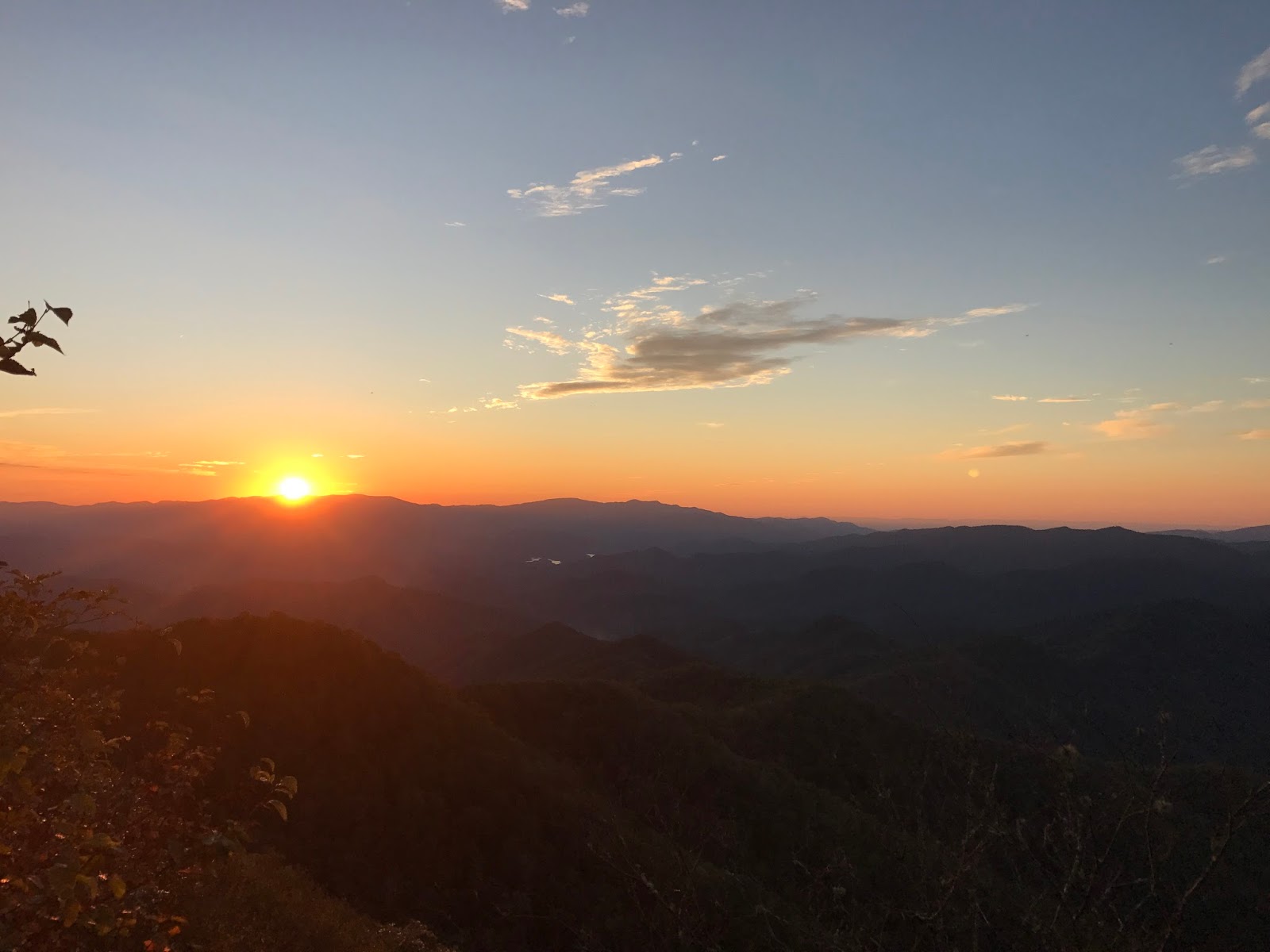
The three of
us sat back and let God take over and dazzle us with a slow burn sunset…


It was the
perfect way to kick off me and Ash’s 2nd annual joint birthday
weekend.

Once the
color started fading from the sky, we began a lively 5 mile descent. As we
bounded down Alum Cave with a distant fire red horizon as our backdrop, I
couldn’t help getting a little emotional. It had been a tough year. Real growth
is hard and sloppy… and this year had been the biggest year I’ve ever had
regarding genuine personal growth. In the end, this adventure, one that I’ve
had my eyes on for years, served as a pleasant reminder of the essence of my
core values and the firm belief that one should always stay true to themselves.
Stay magical.